Hardown Hill, Morcombelake SY 404 944
The Chert Beds of the Upper Greensand have been worked for roadstone and building stone in up to 15 open pits and 3 adits, since medieval days.
The ‘cobs’ were split for building using a small hammer with a long handle – the Hardown hammer. An iron bar with three claws was used to hold the cobs which were hung in wet hessian sacks to save the workman’s eyes, though they also wore wire goggles. The tenants on the hill had the right to two cartloads of hoggin, which was flint, sand and clay for the roads. An open pit is shown on the Tempest House Terrier of 1769, on the eastern side of the road to Whitchurch, and a large one on High Bullen on the tithe map of 1844.
The chert from Hardown can be seen in local buildings such as the churches at Stanton St. Gabriel (14th century), Whitchurch Canonicorum (11th to 19th centuries), Charmouth and Catherston Leweston (both 19th century), and in many domestic and farm buildings throughout the Vale of Marshwood.
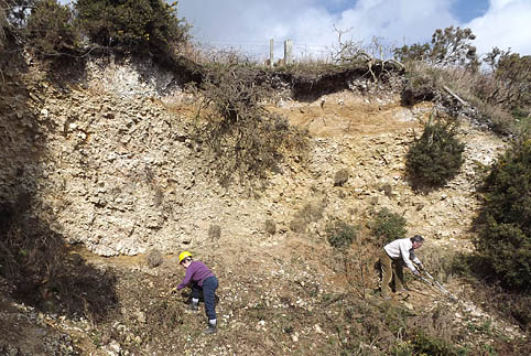
Open pit on Love’s Lane. Measurements by Dr. Mike Cosgrove on 16.3.1998.
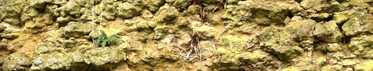
South facing exposure of Upper Greensand, Chert Beds. Cretaceous, Albian, dispar zone.
| A. | 1.10 m | Head. Bleached flints with some clay and sand matrix, under a thin topsoil. |
| B. | .80 m | Sand. Thin bedded glauconitic sand unit, weathering to ochre colour. This bed is a lens shape, having been eroded in pre-Head times. |
| C. | 1.50 m | Rubbly cherts. Nodular and angular chert, pale buff colour, weathering paler. Three larger nodules were measured at 30 cm, 55 cm, 60 cm on their long axes, which were mostly horizontal, or slightly inclined. One nodule, measuring 60 cm was vertical. |
| D. | .03 m | Sandy clay, orange coloured. |
| E. | 1.30 m | Bedded chert units in rubbly matrix. The bedded units are up to 20 cm thick, and can be followed horizontally for up to 3 m before becoming broken by weathering. |
| F. | .70 m | Sandstone unit with irregular top. Lumps of chert penetrate the upper surface, as if dropped into a softer deposit. The unit is dark green to dark brown at top and bottom, with rounded quartz grains up to 2 mm in diameter. In the middle of the ‘sandwich’ is an uneven layer of cream to dark ochre friable sand with hard black stringers (?MnO2). The lower surface of this bed is relatively flat. |
| G. | 1.20 m | Well-bedded cherts with some massive units up to 30 cm thick, with pale sand matrix similar to the middle of the ‘sandwich’ above.(The beds are essentially horizontal in this section.) |
West facing exposure.
| A. | .40 m | Head. Bleached flints and sand with thin soil cover. |
| B to D | Eroded, the Head being draped over the steep hillside. | |
| E. | 1.30 m | Nodular and angular cherts in matrix of small chert, clay and sand. Several nodules were measured on their long axes at 25 cm and 40 cm. |
| F. | .30 m | Sandstone unit, top layer. Ochre coloured sandy clay with green glauconitic patches. |
| .20 m | Sandstone unit, middle. Uneven layer of cream friable sand. | |
| .40 m | Sandstone unit, lower. Thinly bedded, multi coloured clay (brown, buff, pale grey and brick red) with fine sub-mm laminae, within which are lenses of coarse dark green to brown sands. Pronounced black (MnO2) unit at base measuring 2-3 mm.This clay and sandstone sandwich unit cuts across the bedding of the lower units. | |
| G. | .90 m | Bedded cherts with sandy matrix. Nodules (‘cobs’) up to 20 cm thick. Much black mineralisation (? pyrolusite). (The beds appear to dip to the south – this may be ‘sag’ of the strata due to slumping down slope.) |
Access: This pit, and the top of Hardown Hill, are owned by the National Trust, and therefore open access. Educational parties should contact the Charmouth office prior to their visit. If the gate is closed, please keep shut during your visit.
Parking: Take Gibbs Lane on the north side of the main road, and Verriott’s Lane to a small car park near the radio mast. The last part is unmade.
Size of party: 15
Education level: A level/University.
REFERENCES:
Wilson V et al, 1958: Geology of the country around Bridport & Yeovil. Memoir of the Geological Survey of Great Britain. p 152.
15.4.1998. Dr. Mike Cosgrove and Jo Thomas. D.I.G.S.